Add a Feature Layer
Feature services (.../FeatureServer) allow you to serve feature data and nonspatial tables over the internet or your intranet. This makes your data available for use in web clients, desktop apps, and field apps. The layer resource (.../FeatureServer/<layerId>) in a feature service represents a single spatial feature layer or a nonspatial table.
Within Cityworks, the Feature Layer Service Type in Service Resources can be utilized in two different ways—for asset configuration only or for displaying in the map. If you only need the feature layer for asset configuration, then only the core feature service URL (.../FeatureServer) needs to be defined; optionally, the feature layer can also go to the layer resource level (.../FeatureLayer/<layerId>). If the Feature Layer is needed for directly displaying in the map without the use of a wep map, then the URL must go to the layer resource level (.../FeatureLayer/<layerId>) in order for the layer to correctly initialize and draw.
If a feature service (.../FeatureServer) is added using the Feature Layer service resource, it will only be used for asset configuration and will not display on the map. Adding a feature service as a feature layer allows you to use related assets, search for assets, set up services for assets in Service Layers, etc.
 NOTE: To display a feature service on the map, add a web map that contains all of the feature layers from the feature service to a service definition.
- Click the Service Resources tab.
- Click Add on the GIS Service Resources panel.
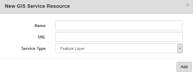
- Enter a Name for the service.
- Enter the URL of the entire feature service.
- Select Feature Layer from the Service Type drop-down list and click Add.
- Select the new resource from the GIS Service Resources panel to finish entering the Resource Details.
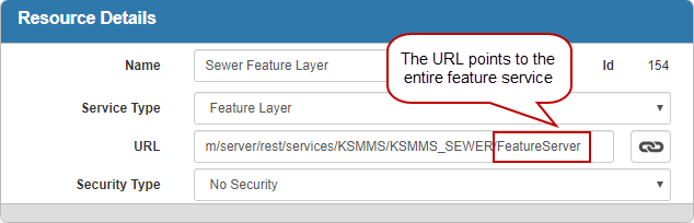
The Id, a unique number assigned to the service resource, appears to the right of the resource Name.
- Select the Security Type, either No Security, OAuth2 App, OAuth2 User, or Token.
See Configure Service Resource Security for more information on security types.
- Click open service link next to the URL field to quickly check the service connection.
Once the feature layer is added as a resource, you can start configuring services for the asset layers in Service Layers. See Configure Service Layers for more information.
In order to directly display a feature layer on the map without the use of a web map, it must point to a specific layer in a feature service (.../FeatureServer/<layerId>).
NOTE: If the layer points to a table, it will not display on the map.
- Click the Service Resources tab.
- Click Add on the GIS Service Resources panel.
- Enter a Name for the service.
- Enter the URL of the service that points to a specific layer.
- Select Feature Layer from the Service Type drop-down list and click Add.
- Select the new resource from the GIS Service Resources panel to finish entering the Resource Details.
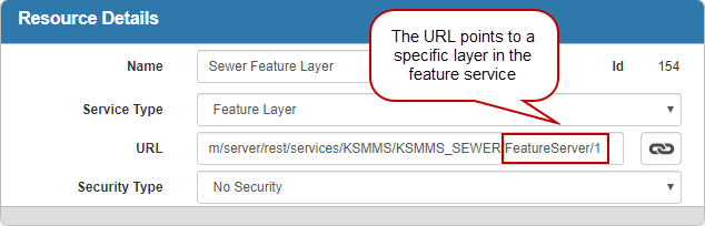
The Id, a unique number assigned to the service resource, appears to the right of the resource Name.
- Select the Security Type, either No Security, OAuth2 App, OAuth2 User, or Token.
See Configure Service Resource Security for more information on security types.
- Click open service link next to the URL field to quickly check the service connection.
Once the feature layer is added as a resource, add it to a Service Definition to view it on the map. See Add Services to a Service Definition for more information.
NOTE: Designer automatically saves the changes you make. A notification will appear in the top-right corner of the window that says Data Saved when you make changes to the page.