Configure GPS Metadata
Trimble GPS units can be used to capture an accurate location of the inspection. Then you can configure the mapping of that GPS information and metadata to update the GIS. This is configured in Admin with two parts: Metadata Configuration and Asset Mapping.
The metadata configuration determines the data structure for the information sent from Cityworks to the GIS.
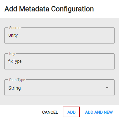
- In Admin on the Admin tab, navigate to Metadata Configuration.
- Click Add record.
- Enter a name in the Source field, such as Unity.
- Enter a name in the Key field, such as fixType.
- Select the Data Type for this configuration.
The Key and Data Type represent the data structure in the metadata configuration. This tells Cityworks how to convert the value from Cityworks to the GIS.
- Click Add.
The table below shows the possible GPS key values for metadata configurations.
|
Key |
Data Type |
Mapping Value |
|---|---|---|
|
antennaHeight |
Double |
Unity.antennaHeight |
|
correctionAge |
Integer |
Unity.correctionAge |
|
dateTime |
DateTime |
Unity.dateTime |
|
fixType |
String |
Unity.fixType |
|
geoidHeight |
Double |
Unity.geoidHeight |
|
geoidModel |
String |
Unity.geoidModel |
|
hae |
Double |
Unity.hae |
|
hamsl |
Double |
Unity.hamsl |
|
hdop |
Double |
Unity.hdop |
|
horizontalAccuracy |
Double |
Unity.horizontalAccuracy |
|
pdop |
Double |
Unity.pdop |
|
rawX |
Double |
Unity.rawX |
|
rawY |
Double |
Unity.rawY |
|
rtkStatus |
String |
Unity.rtkStatus |
|
satellites |
Integer |
Unity.satellites |
|
source |
String |
Unity.source |
|
tilt |
Double |
Unity.tilt |
|
tiltTolerance |
Double |
Unity.tiltTolerance |
|
tiltToleranceUnit |
String |
Unity.tiltToleranceUnit |
|
tiltX |
Double |
Unity.tiltX |
|
tiltY |
Double |
Unity.tiltY |
|
vdop |
Double |
Unity.vdop |
|
verticalAccuracy |
Double |
Unity.verticalAccuracy |
|
X |
Double |
Unity.X |
|
Y |
Double |
Unity.Y |
For more information on metadata configurations, see Metadata Configuration in the Admin 2.2 Guide.
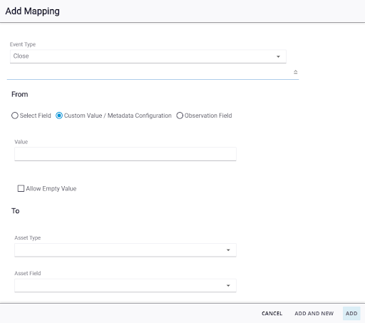
The GIS field to be updated from the inspection is configured under Asset Mapping.
- In Admin on the GIS tab, navigate to Asset Mapping.
- Click the Inspection Templates tab.
- Select the inspection template and click Add record.
- In the Add Mapping panel, select Close from the Event Type drop-down list to update the GIS when the inspection is closed in Cityworks.
- Select Custom Value/Metadata Configuration.
- Enter the metadata configuration in the Value field, formatted as <source>.<key> (the name of the metadata configuration Source and Key, separated by a period). The values are filtered as you type. For Trimble Unity mobile, the Source will be Unity. An example Value is Unity.horizontalAccuracy.
- Select the Asset Type and Asset Field to indicate which field will be updated when the inspection is closed.
- Select Allow Empty Values if you want to allow the Asset Field to be updated with an empty value. To prevent the Asset Field from being updated with an empty value, do not select Allow Empty Value.
- Click Add.